The Australian prime minister has warned there is "worse to come" after a low tropical weather system brought heavy rain, strong winds and flooding to the country's east coast.
Anthony Albanese said the impacts of ex-Tropical Cyclone Alfred are already being felt across parts of Queensland and New South Wales, with the hours ahead expected to bring more downpours.
"We must remain vigilant. This is a very serious weather event," he said in an update on Saturday morning.
"The impact will be serious and will intensify over coming hours and coming days. [It will] still bring strong winds, heavy rain, flooding and dangerous conditions over this weekend and the days beyond.
"Now is the time to remain alert, stay inside and look after each other."
Police confirmed that a 61-year-old man who disappeared in a flooded river near the town of Dorrigo in New South Wales had died after his body was recovered on Saturday.
Please use Chrome browser for a more accessible video player

Tropical Cyclone Alfred had been expected to become the first cyclone to cross the east Australian coast near the Queensland state capital since 1974.
But the weather event weakened early on Saturday to a tropical low, which is defined as carrying sustained winds of less than 39mph.
The cyclone came to a near-standstill off the Brisbane coast for several hours on the first day of the weekend, but it is still forecast to track west across the Australian mainland in the coming days, bringing heavy rain, Matt Collopy, manager at Australia's Bureau of Meteorology, said.
Read more: What we know about storm nearing Australian coast

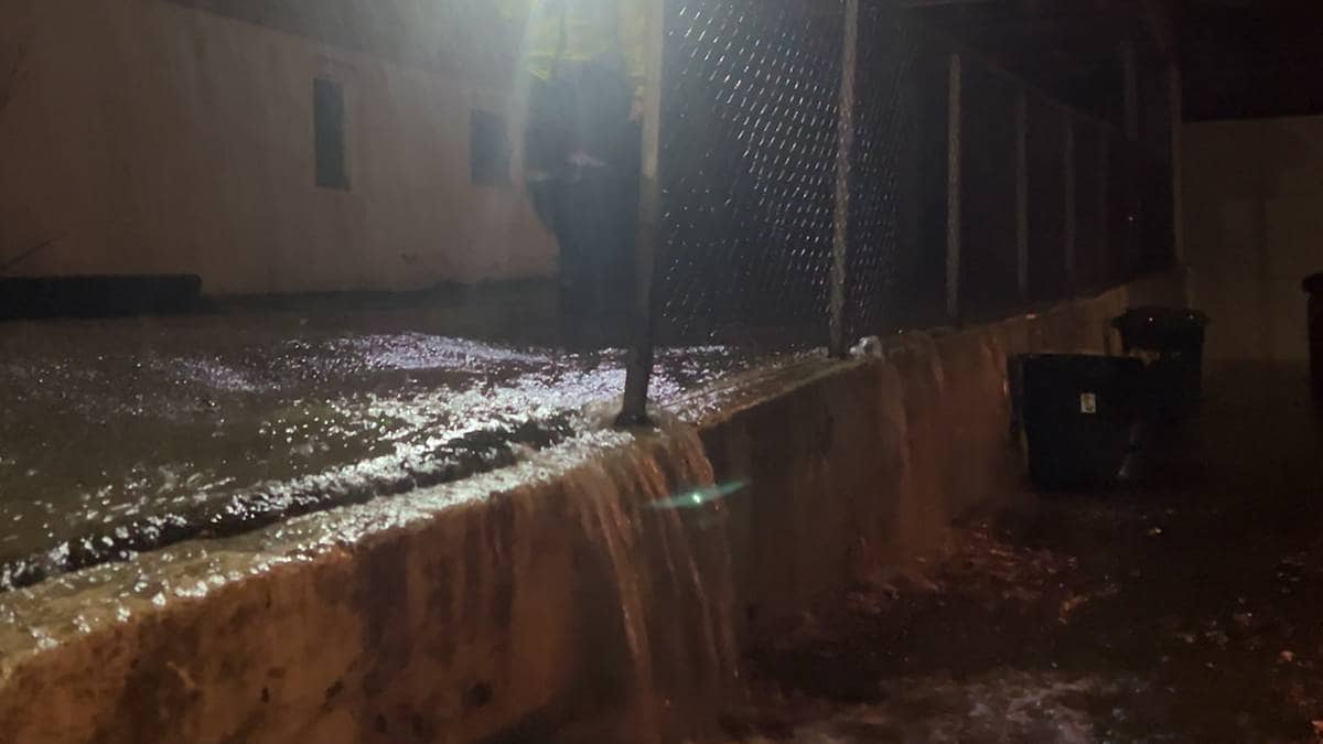
Fallen trees across the region have already damaged power lines, homes and cars, while the Gold Coast's renowned beaches have become steep sandy cliffs after days of relentless erosion.
A number of flood warnings are in place across the east coast, with the Bureau of Meteorology Australia warning that "rivers are rising rapidly" and flash floods also pose a "huge risk".
The national forecaster said the peak of flooding is expected to be overnight on Saturday into early Sunday.
X This content is provided by X, which may be using cookies and other technologies. To show you this content, we need your permission to use cookies. You can use the buttons below to amend your preferences to enable X cookies or to allow those cookies just once. You can change your settings at any time via the Privacy Options. Unfortunately we have been unable to verify if you have consented to X cookies. To view this content you can use the button below to allow X cookies for this session only.
Mr Albanese warned people not to take the weather downgrade as a reason to be complacent, adding that the advice of his government remains: "If it's flooded, forget it."
Sarah Ndiaye, the mayor of Byron Shire in New South Wales, told Sky News that the region had "dodged a bullet" after the cyclone didn't hit as expected, but it remains a "very, very tense" situation.

An estimated 19,000 people have been evacuated from low-lying homes. In Queensland, a woman sustained minor injuries when an apartment building lost its roof, officials said.
She was one of 21 people who were evacuated from the building.
Two other people narrowly escaped a large tree falling on their home in the Currumbin Valley in Queensland on Thursday night. They were lying only inches from where the tree came to rest in their bedroom, they said, adding both suffered minor injuries.
Region's 'largest ever loss of power'
More than 330,000 homes and businesses lost power on both sides of the border, a large proportion of them on the Gold Coast, which recorded the strongest gusts of 107kph (66 mph) on Friday night.
X This content is provided by X, which may be using cookies and other technologies. To show you this content, we need your permission to use cookies. You can use the buttons below to amend your preferences to enable X cookies or to allow those cookies just once. You can change your settings at any time via the Privacy Options. Unfortunately we have been unable to verify if you have consented to X cookies. To view this content you can use the button below to allow X cookies for this session only.
Queensland Premier David Crisafulli said the outage is the "largest ever loss of power from a natural disaster" in the region's history.
He said authorities and emergency services are "throwing everything" at restoring power to those affected and clearing roads that have been blocked by fallen debris.
Read more from Sky News:
Survivor reflects on five years on from COVID
At least 12 people injured in shooting in Toronto
In its latest forecast, the Bureau of Meteorology Australia said areas experiencing the heaviest rainfall could see up to 200-300mm of rain in the next 24 hours with isolated wind gusts of up to 90kph (55mph).
A severe weather warning is in place for "heavy to locally intense rainfall" and "damaging winds", covering areas to the south of Gympie in Queensland all the way down to Nambucca Heads in New South Wales.
The forecaster said a "gradual easing" of the intense rainfall should be seen by Monday night, but this depends on how the system moves across the country.


 English (US) ·