Warning: session_start(): open(/home/nortodco/public_html/rss4/src/var/sessions/sess_8f47dc90d21acf5bd1ee53e37243a0f6, O_RDWR) failed: No space left on device (28) in /home/nortodco/public_html/rss4/src/bootstrap.php on line 59

Warning: session_start(): Failed to read session data: files (path: /home/nortodco/public_html/rss4/src/var/sessions) in /home/nortodco/public_html/rss4/src/bootstrap.php on line 59
The bizarre details hidden in a 16th-century map of Iceland - NorwayToday

The bizarre details hidden in a 16th-century map of Iceland

16 hours ago 3


Who knew Iceland could be so dangerous? Abraham Ortelius’ redrawing of Iceland in 1585 forever changed how Europe viewed this distant island in the Atlantic. By using local sources, Ortelius was able to draw accurate coastlines and fill his new map with fascinating and terrifying information, making this one of the most beautiful and striking maps of Iceland ever printed.

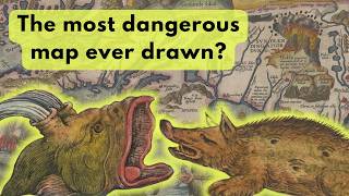
Learn about the monstrous sea creatures inhabiting Iceland's waters, the gateway to hell, how foxes hunted bird eggs, and the spring of beer you can still visit today.

High-resolution map & description: https://hdl.handle.net/10037.2/603
Further reading: https://mapmyths.com/blog/islandia/
Olaus Magnus and Carta Marina: https://youtube.com/shorts/oEUlWon6RQE?feature=share

0:00 Abraham Ortelius and Islandia
0:42 A catalogue of sea monsters
3:43 The land of ice and fire: Hekla
4:39 Glaciers and other details of Iceland
6:12 Ortelius’ sources and Bishop Gudbrandur Thorláksson
7:20 Outro
Read Entire Article