Breathing has become "painful" for people in Indonesia after a large lava and ash cloud formed as a volcano erupted, causing flights to be cancelled, schools to close and sending people running for shelter amid difficult driving conditions.
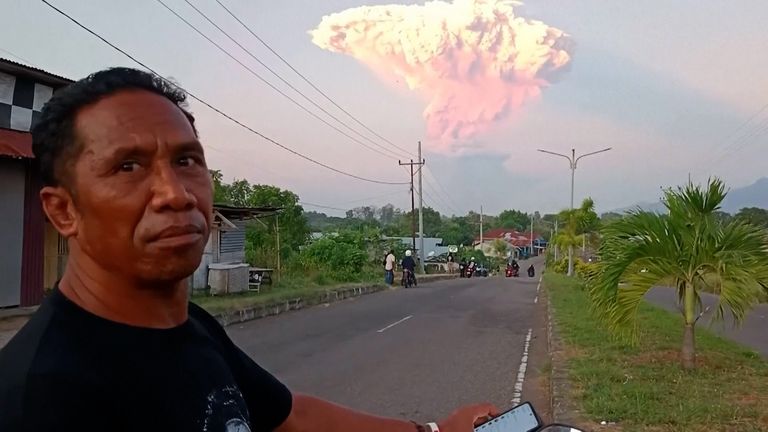
Thick volcanic ash covered roads and rice fields in villages in south-central Indonesia as lava and ash clouds were sent up to 4km (2.4 miles) as Mount Lewotobi Laki Laki on Flores Island erupted for the second day running, at dawn local time on Tuesday.
Debris was recorded as going up to 18km (11 miles) 13km (eight miles) into the air when the eruptions began at around noon on Monday.
Gaza ceasefire latest - Trump's view on talks progress


Local people were told to limit time spent outdoors as roads and green rice fields became grey thick mud and rocks and schools in the affected areas had been closed since Monday, public information official Very Awales said.
"The smell of sulfur and ash hung so thickly in the air that breathing was painful," he said.
No injuries or deaths were reported, but pictures and videos posted on social media showed people running for their lives under the rain of ash and gravel, and car and motorbike drivers struggling in reduced visibility caused by the large mushroom-shaped ash cloud Monday's eruption created.
Please use Chrome browser for a more accessible video player
Mount Lewotobi Laki Laki has been at the highest alert level since 18 June when a no-go zone around it was expanded to 7km (4.3 miles), Abdul Muhari, the National Disaster Mitigation Agency spokesperson said.
More than 10,000 people in 10 villages in East Flores and Sikka districts have been affected, according to initial assessments by the local disaster management agency.
Airports in the cities of Maumere and Larantuka in East Nusa Tenggara province were still closed on Tuesday, Mr Muhari said, and dozens of flights to and from the Ngurah Rai International Airport on the resort island of Bali were delayed or cancelled.
Read more on Sky News:
New pictures of Texas floods
Norman Tebbit dies
Issues at 'Alligator Alcatraz'
Nine people died and dozens more were injured after the volcano erupted in November.
In 2010, more than 350 people were killed and hundreds of thousands forced to leave their homes after Mount Merapi, the country's most volatile volcano, erupted on the densely populated island of Java.
Indonesia, which has 120 active volcanoes, sits along the so-called Ring of Fire, a horseshoe-shaped series of seismic fault lines around the Pacific Basin.


 English (US)